
Volume 11, Issue 2 (June 2026)
J Environ Health Sustain Dev 2026, 11(2): 3008-3021 |
Back to browse issues page



Download citation:
BibTeX | RIS | EndNote | Medlars | ProCite | Reference Manager | RefWorks
Send citation to:


BibTeX | RIS | EndNote | Medlars | ProCite | Reference Manager | RefWorks
Send citation to:
Akpan D N, Akpan A D, Ekpo S S, Edem M E. Assessment of Ambient Ionizing Radiation Dose Rates and Radiological Risks in Selected Municipal Dumpsites of Akwa Ibom State, Nigeria. J Environ Health Sustain Dev 2026; 11 (2) :3008-3021
URL: http://jehsd.ssu.ac.ir/article-1-1017-en.html
URL: http://jehsd.ssu.ac.ir/article-1-1017-en.html


University of Uyo, Uyo, Akwa Ibom State, Nigeria
Full-Text [PDF 822 kb]
(158 Downloads)
| Abstract (HTML) (558 Views)
Table 1: Dumpsites and GPS Co-ordinates.
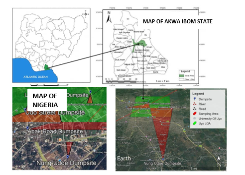
Figure 1: Map of the study site.
Table 2: Measured exposure rate and calculated radiological hazard indices at Uyo Village Road dumpsite.
Table 4: Measured exposure rate and calculated radiological hazard indices at Nwaniba Road dumpsite.
Table 5: Measured exposure rate and calculated radiological hazard indices at Abak Road dumpsite.
Table 6: Measured exposure rate and calculated radiological hazard indices at Udo Street dumpsite.
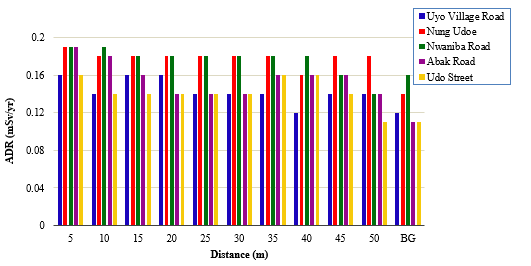
Figure 2: Variation of the annual dose rate (ADR) with distance for all dumpsites.
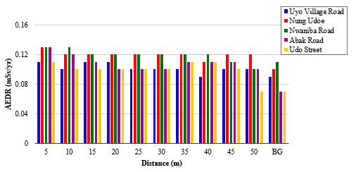
Figure 3: Variation of the annual effective dose rate (AEDR) with distance for all dumpsites.
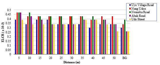
Figure 4: Variation in excess lifetime cancer risk (ELCR) with distance for all dumpsites.
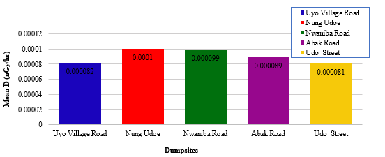
Figure 5: Mean absorbed dose rate (D in nGy/hr) for different municipal dumpsites.
Full-Text: (85 Views)
Assessment of Ambient Ionizing Radiation Dose Rates and Radiological Risks in Selected Municipal Dumpsites of Akwa Ibom State, Nigeria
Dianabasi Nkereuwem Akpan 1*, Akanimo Dianabasi Akpan 2, Sunday Samuel Ekpo 1, Michael Ephraim Edem 1
1 University of Uyo, Uyo, Akwa Ibom State, Nigeria.
2 Akwa Ibom State University, Ikot Akpaden, Mkpat Enin, Nigeria.
Dianabasi Nkereuwem Akpan 1*, Akanimo Dianabasi Akpan 2, Sunday Samuel Ekpo 1, Michael Ephraim Edem 1
1 University of Uyo, Uyo, Akwa Ibom State, Nigeria.
2 Akwa Ibom State University, Ikot Akpaden, Mkpat Enin, Nigeria.
| A R T I C L E I N F O | ABSTRACT | |
| Systematic Review | Introduction: Over the years, some municipal dumpsites have been found to exhibit ionizing radiation due to indiscriminate dumping of hazardous refuse. Materials and Methods: An ionizing radiation survey of five municipal dumpsites in Akwa Ibom State was conducted to measure elevated radiation levels. The five dumpsites were Uyo Village Road, Nung Udoe, Nwaniba Road, Abak Road, and Udo Street. Radiation exposure at each dumpsite was measured using a Digilert 200 radiation survey meter. Results: For the Uyo Village Road dumpsite, the mean Absorbed Dose Rate (D), mean Annual Effective Dose Rate (AEDR), and mean Excess Lifetime Cancer Rate (ELCR) were 8.2 x 10⁻⁵ nGy/hr, 0.10 mSv/yr, and 0.35 x 10⁻³ respectively. For the Nung Udoe dumpsite, the mean D, AEDR, and ELCR were 1.0 x 10⁻⁴ nGy/hr, 0.12 mSv/yr, and 0.43 x 10⁻³ respectively. For the Nwaniba Road dumpsite, the mean D, AEDR, and ELCR were 9.9 x 10⁻⁵ nGy/hr, 0.12 mSv/yr, and 0.43 x 10⁻³ respectively. For the Abak Road dumpsite, the mean D, AEDR, and ELCR were 8.9 x 10⁻⁵ nGy/hr, 0.11 mSv/yr, and 0.38 x 10⁻³ respectively. For the Udo Street dumpsite, the mean D, AEDR, and ELCR were 8.2 x 10⁻⁵ nGy/hr, 0.10 mSv/yr, and 0.35 x 10⁻³ respectively. The mean Ds and AEDRs were far below the world average limit of 59 nGy/hr and 1 mSv/yr for the public, respectively. Conclusion: The reported values do not have any immediate radiological health hazards; however, residents and workers should reduce the hours spent at the dumpsites. |
|
Article History: Received: 10 March 2026 Accepted: 20 May 2026 |
||
*Corresponding Author: Dianabasi Nkereuwem Akpan Email: dianabasiakpan@uniuyo.edu.ng Tel: +23 48038685545 |
||
Keywords: Assessment, Ionizing, Dumpsites, Radiological Risk, Absorbed Dose. |
Citation: Nkereuwem Akpan D, Dianabasi Akpan A, Samuel Ekpo S, et al. Assessment of Ambient Ionizing Radiation Dose Rates and Radiological Risks in Selected Municipal Dumpsites of Akwa Ibom State, Nigeria. J Environ Health Sustain Dev. 2026; 11(2): 3008-21.
Introduction
Ionizing radiation exists in both natural and artificial (man-made) forms. Natural sources of ionizing radiation appear to play a smaller role in the effects on ecosystems than artificial radiation sources. An artificial source of ionizing radiation is a hazardous waste. Waste generation is rapidly increasing 1 due to technological advancement, many wastes are generated and the societies become structured where almost all nations are moving from rural agrarian Societies to Urban 2, 3, 4. Human activities, industrialization, and population growth in most cities in Nigeria have resulted in the generation of huge quantities of waste, which are not properly managed 5. As the quantity of waste produced in cities continues to increase daily, the effectiveness of waste management in terms of collection and disposal remains undesirably low in most parts 6, 7. It was noted that municipal, commercial, and household waste, such as food, plastic, paper textiles, scrap metals, polyethylene, glass, wood, paints, and insecticide cans, accumulated at street corners and gutters and had the likelihood of generating radioactivity 8. The dumped waste is detrimental to human health and other living organisms in the ecosystem. Nevertheless, the hazards posed by dumpsites situated in the environment, do not only result in the production of offensive odours and disease producing micro-organisms, but can also arise from the radiation emanating from the dumpsites 9, 10, 11, 12, 13. Since these wastes are indiscriminately dumped, the dumped area becomes vulnerable to diseases because it becomes a harbor for mosquitoes, flies, emission of methane gas, unpleasant odors, and all kinds of animals that serve as vectors transmitting diseases through the food chain to humans and the environment 14. Unfortunately, most foods consumed by Nigerians carry traces of radionuclides, and as a result, refuse dumpsites are variable recipients of radioactive materials 15. People living around or working at dumpsites are adversely affected by worms and gastrointestinal parasites 16. Even though humans have been fed with a balanced diet, they find it difficult to attain a healthy state because radiation has infiltrated the consumed food. This has led to many ailments in the world, some of which are very strange. Omokaro et al.7 examined the time taken environmental and health implications of improper disposal practices and management of hazardous materials at dumpsites.
Individuals chronically exposed to low-level ionizing radiation from dumpsites have specific health risks, which could be deterministic or stochastic effects or both. Deterministic effects have a threshold dose below which no ionizing effect occurs. The severity of these effects increases with dose, once the threshold is exceeded. The accumulation of these doses over a long period can lead to cataracts of the eye lens, skin changes (erythema), and reduced fertility. In stochastic effects (probabilistic), there is no threshold dose because even small doses carry some risks. The probability of these effects increases with dose, but the severity does not. They cause damage to deoxyribonucleic acid (DNA), which may not be repaired, resulting in mutations. The specific health risks of stochastic effects are cancer (e.g., leukemia, lung, thyroid, and breast cancers) and hereditary genetic effects.
Assessment of ambient ionizing dose rates and radiological risks in selected municipal dumpsites in Akwa Ibom State is necessary because dumpsites are frequently accessed by scavengers, waste workers, and nearby residents who may be chronically exposed to low-level ionizing radiation. Assessing dose rates helps to determine possible health risks, particularly long-term cancer risk. Moreover, radioactive materials in dumpsites can contaminate soil, surface water, and groundwater through leaching, leading to widespread environmental and food chain contamination. There is also limited information on background radiation levels in some of these municipal dumpsites; therefore, this study provides baseline data for future monitoring and comparison.
In light of the aforementioned problems, this study will survey municipal dumpsites to measure their elevated ionizing radiation levels and determine whether these levels exceed international safety standards; to compare ionizing radiation levels across different dumpsites to identify potential sources of contamination; and to assess the potential public health risks associated with ionizing radiation exposure from municipal dumpsites. When these are completed, data will be provided as part of environmental monitoring research for the proper assessment of the ionizing radiation exposure rate of the metropolis. Information will be provided to ionizing radiation workers and people living around dumpsites to safeguard themselves against unnecessary ionizing radiation exposure.
Materials and Methods
Study Area Description
This study was conducted at five municipal dumpsites in Akwa Ibom State, Nigeria. Akwa Ibom State is in the south-south geopolitical zone of Nigeria, bordered by Cross River State to the East, Abia State to the North, Rivers State to the West, and the Atlantic Ocean to the South. The state experiences a humid tropical climate characterized by high rainfall, warm temperatures, and dense vegetation, making it vulnerable to environmental pollution and waste management challenges.
The five selected dumpsites were Uyo Village Road, Nung Udoe, Nwaniba Road, Abak Road, and Udo Street. All the dumpsites were located in Uyo Local Government Area (L.G.A.) except Nung Udoe dumpsite, which was located in Ibesikpo Austan L.G.A.. Table 1 shows the dumpsites and locations, indicating their respective latitudes longitudes using geographical positioning system (GPS) coordinates. These locations were chosen because of their high volume of waste accumulation, presence of scavengers, and proximity to residential and commercial areas, making them ideal for assessing ionizing radiation exposure levels. The dumpsites receive a mix of organic, industrial, and hazardous waste, some of which may contain naturally occurring radioactive materials (NORMs). Their proximity to human settlements, farmlands, and water sources raises concerns about long-term environmental contamination and public health risks, making them critical locations for this study.
Ionizing radiation exists in both natural and artificial (man-made) forms. Natural sources of ionizing radiation appear to play a smaller role in the effects on ecosystems than artificial radiation sources. An artificial source of ionizing radiation is a hazardous waste. Waste generation is rapidly increasing 1 due to technological advancement, many wastes are generated and the societies become structured where almost all nations are moving from rural agrarian Societies to Urban 2, 3, 4. Human activities, industrialization, and population growth in most cities in Nigeria have resulted in the generation of huge quantities of waste, which are not properly managed 5. As the quantity of waste produced in cities continues to increase daily, the effectiveness of waste management in terms of collection and disposal remains undesirably low in most parts 6, 7. It was noted that municipal, commercial, and household waste, such as food, plastic, paper textiles, scrap metals, polyethylene, glass, wood, paints, and insecticide cans, accumulated at street corners and gutters and had the likelihood of generating radioactivity 8. The dumped waste is detrimental to human health and other living organisms in the ecosystem. Nevertheless, the hazards posed by dumpsites situated in the environment, do not only result in the production of offensive odours and disease producing micro-organisms, but can also arise from the radiation emanating from the dumpsites 9, 10, 11, 12, 13. Since these wastes are indiscriminately dumped, the dumped area becomes vulnerable to diseases because it becomes a harbor for mosquitoes, flies, emission of methane gas, unpleasant odors, and all kinds of animals that serve as vectors transmitting diseases through the food chain to humans and the environment 14. Unfortunately, most foods consumed by Nigerians carry traces of radionuclides, and as a result, refuse dumpsites are variable recipients of radioactive materials 15. People living around or working at dumpsites are adversely affected by worms and gastrointestinal parasites 16. Even though humans have been fed with a balanced diet, they find it difficult to attain a healthy state because radiation has infiltrated the consumed food. This has led to many ailments in the world, some of which are very strange. Omokaro et al.7 examined the time taken environmental and health implications of improper disposal practices and management of hazardous materials at dumpsites.
Individuals chronically exposed to low-level ionizing radiation from dumpsites have specific health risks, which could be deterministic or stochastic effects or both. Deterministic effects have a threshold dose below which no ionizing effect occurs. The severity of these effects increases with dose, once the threshold is exceeded. The accumulation of these doses over a long period can lead to cataracts of the eye lens, skin changes (erythema), and reduced fertility. In stochastic effects (probabilistic), there is no threshold dose because even small doses carry some risks. The probability of these effects increases with dose, but the severity does not. They cause damage to deoxyribonucleic acid (DNA), which may not be repaired, resulting in mutations. The specific health risks of stochastic effects are cancer (e.g., leukemia, lung, thyroid, and breast cancers) and hereditary genetic effects.
Assessment of ambient ionizing dose rates and radiological risks in selected municipal dumpsites in Akwa Ibom State is necessary because dumpsites are frequently accessed by scavengers, waste workers, and nearby residents who may be chronically exposed to low-level ionizing radiation. Assessing dose rates helps to determine possible health risks, particularly long-term cancer risk. Moreover, radioactive materials in dumpsites can contaminate soil, surface water, and groundwater through leaching, leading to widespread environmental and food chain contamination. There is also limited information on background radiation levels in some of these municipal dumpsites; therefore, this study provides baseline data for future monitoring and comparison.
In light of the aforementioned problems, this study will survey municipal dumpsites to measure their elevated ionizing radiation levels and determine whether these levels exceed international safety standards; to compare ionizing radiation levels across different dumpsites to identify potential sources of contamination; and to assess the potential public health risks associated with ionizing radiation exposure from municipal dumpsites. When these are completed, data will be provided as part of environmental monitoring research for the proper assessment of the ionizing radiation exposure rate of the metropolis. Information will be provided to ionizing radiation workers and people living around dumpsites to safeguard themselves against unnecessary ionizing radiation exposure.
Materials and Methods
Study Area Description
This study was conducted at five municipal dumpsites in Akwa Ibom State, Nigeria. Akwa Ibom State is in the south-south geopolitical zone of Nigeria, bordered by Cross River State to the East, Abia State to the North, Rivers State to the West, and the Atlantic Ocean to the South. The state experiences a humid tropical climate characterized by high rainfall, warm temperatures, and dense vegetation, making it vulnerable to environmental pollution and waste management challenges.
The five selected dumpsites were Uyo Village Road, Nung Udoe, Nwaniba Road, Abak Road, and Udo Street. All the dumpsites were located in Uyo Local Government Area (L.G.A.) except Nung Udoe dumpsite, which was located in Ibesikpo Austan L.G.A.. Table 1 shows the dumpsites and locations, indicating their respective latitudes longitudes using geographical positioning system (GPS) coordinates. These locations were chosen because of their high volume of waste accumulation, presence of scavengers, and proximity to residential and commercial areas, making them ideal for assessing ionizing radiation exposure levels. The dumpsites receive a mix of organic, industrial, and hazardous waste, some of which may contain naturally occurring radioactive materials (NORMs). Their proximity to human settlements, farmlands, and water sources raises concerns about long-term environmental contamination and public health risks, making them critical locations for this study.
Table 1: Dumpsites and GPS Co-ordinates.
| Dumpsite | Location | Latitude | Longitude |
| Uyo Village Road Dumpsite | Uyo Village Road, Uyo | 5.04725° N | 7.93700° E |
| Nung Udoe Dumpsite | Nung Udoe, Ibesikpo Asutan | 4.91877° N | 7.96460° E |
| Nwaniba Road, Uyo Dumpsite | Nwaniba Road, Uyo | 5.02609° N | 7.98378° E |
| Abak Road Dumpsite | Abak Road, Uyo | 5.02664° N | 7.89847° E |
| Udo Street Dumpsite | Udo Street, Uyo | 5.04131° N | 7.93550° E |
The Uyo Village Road dumpsite is a major waste disposal site located in Uyo Metropolis, serving residential neighborhoods and markets. It is one of the busiest dumpsites because of its accessibility and the large volume of waste generated daily. Figure.1 shows a map of the study area.
Nung Udoe dumpsite is situated in Ibesikpo Asutan L.G.A., a semi-urban settlement that receives waste from multiple communities. This location is surrounded by farmlands and water bodies, increasing the potential for ionizing radiation contamination of soil and agricultural produce.
The Nwaniba Road dumpsite is located along Nwaniba, a major route connecting Uyo to tourist and educational centers, including the University of Uyo (Main Campus). This receives a high volume of waste and is frequently visited by scavengers and informal waste recyclers.
The Abak Road dumpsite serves communities along the western parts of Uyo, an area undergoing rapid urban development. Due to the increasing population density, this site has experienced growing concerns regarding waste management and environmental pollution.
Udo Street dumpsite is located in the heart of Uyo town, surrounded by residential areas, commercial hubs, and marketplaces. The presence of large amounts of organic industrial hazardous waste makes this site particularly susceptible to pollution and ionizing radiation hazards. Waste scavengers, and local traders have easy access to these waste materials; therefore, the potential for prolonged exposure to radioactive materials and other toxic pollutants is a significant concern. Figure. 1 shows a map of the five dumpsites at different locations in Akwa Ibom State, Nigeria.
Nung Udoe dumpsite is situated in Ibesikpo Asutan L.G.A., a semi-urban settlement that receives waste from multiple communities. This location is surrounded by farmlands and water bodies, increasing the potential for ionizing radiation contamination of soil and agricultural produce.
The Nwaniba Road dumpsite is located along Nwaniba, a major route connecting Uyo to tourist and educational centers, including the University of Uyo (Main Campus). This receives a high volume of waste and is frequently visited by scavengers and informal waste recyclers.
The Abak Road dumpsite serves communities along the western parts of Uyo, an area undergoing rapid urban development. Due to the increasing population density, this site has experienced growing concerns regarding waste management and environmental pollution.
Udo Street dumpsite is located in the heart of Uyo town, surrounded by residential areas, commercial hubs, and marketplaces. The presence of large amounts of organic industrial hazardous waste makes this site particularly susceptible to pollution and ionizing radiation hazards. Waste scavengers, and local traders have easy access to these waste materials; therefore, the potential for prolonged exposure to radioactive materials and other toxic pollutants is a significant concern. Figure. 1 shows a map of the five dumpsites at different locations in Akwa Ibom State, Nigeria.
Figure 1: Map of the study site.
Radiation Dose Measurement
Ionizing radiation exposure was measured using a Digilert 200 Radiation Survey Meter, a portable Geiger-Muller (GM) counter manufactured in the United States of America by S. E. International INC. (Serial Number: 600030). The Digilert 200 Radiation Survey Meter is typically factory-calibrated using a traceable gamma source (Cs-137) at energies representative of the environmental gamma field. Factory calibration is usually traceable to the National Institute of Standards and Technology (NIST) standards. Calibration establishes the relationship between the count rate (CPM) measured by the GM tube and the dose equivalent rate (µSv/h or mSv/yr) displayed by the instrument. The Digilert-200 m uses an internal conversion factor based on an approximation:
1µSv/hr = 100 CPM (gamma radiation)
This factor converts the detected counts to dose equivalents, assuming gamma energies typical of natural radionuclides (40 K, Ra-, and Th-series) and a uniform radiation field in ambient air. For low-level environmental measurements, the combined uncertainty of GM-based survey meters is typically in the range of ± 15 – 25%, which is acceptable for screening-level environmental radiation assessments. To minimize random errors, multiple readings were taken at each location and averaged. Radiation exposure was initially measured in counts per minute (CPM), which was later converted to micro-sieverts per hour (μSv/h) for analysis. Each dumpsite was divided into sectors or grids for systematic ionizing radiation measurements. This ensured a representative survey across the entire site. The radiation metre was placed at gonad level about 1 m above ground level while taking readings 9, 11, 17, 18, 19. A control ionizing radiation reading was obtained at each site before further data collection. Ten (10) ionizing radiation readings were recorded at each dumpsite at 5-metre intervals to assess spatial variations in ionizing radiation levels. Ten measurement points per site were selected because low-level ionizing radiation was measured, and it does not have a high penetrating power. These are gamma radiations from dumpsites (mainly natural radionuclides such as 40k, 226Ra, and 232Th), which decrease rapidly with distance owing to geometric spreading (when considering the inverse square law) and absorption and scattering by air, soil, and surrounding materials. Large distance measurements are not required because, beyond a certain distance, the ionizing radiation levels approach the natural background radiation.
The measurement of ionizing radiation level was carried out between 1pm and 4pm to minimize fluctuations due to atmospheric and environmental factors 20, 21. However, the measurements of ionizing radiation between 1pm and 4pm may introduce bias due to diurnal variation of terrestrial radon exhalation, which is often higher in the early morning. Radon (Rn) exhalation from soil and waste material exhibits diurnal variability, which is driven by soil temperature gradients, atmospheric stability, moisture content, and pressure changes. The following implications may arise because the measurements were taken in the afternoon: the recorded ambient dose rates may represent conservative or lower-bound estimates of radiation levels associated with radon progeny; any contribution of radon and its decay products to the measured gamma dose rate may be underestimated relative to morning conditions; the long-lived terrestrial radionuclides (40k, 226Ra, and 232Th) dominate the external gamma radiation field, and their contribution is large time-independent, reducing the magnitude of this bias. Despite the potential bias, this limitation is often accepted for the following reasons: all measurements were taken within the same time window, ensuring internal consistency and comparability across locations and distances; radon primarily affects internal exposure through inhalation rather than external gamma dose rates measured by survey meters; and many environmental radiation surveys adopt afternoon measurements to minimize short-term atmospheric fluctuations and improve reproducibility.
Meteorological conditions, such as wind speed and direction, play an important role in the dispersion, transport, and measured concentration of radon and its short-lived progeny in the atmosphere. Higher wind speeds enhance atmospheric mixing and dilution, leading to lower near-surface Rn concentrations by dispersing Rn away from its source area. Conversely, low wind speeds or calm conditions favor radon accumulation close to the ground, resulting in higher measured concentrations of radon and its progeny. The wind direction controls the horizontal transport of radon-laden air masses. Areas located downwind of a radon source may experience elevated concentrations, whereas upwind locations typically show lower levels. When radon decay products are readily attached to aerosols, wind influences both aerosol transport and deposition, affecting the local concentration of progeny and, hence, the external gamma dose contribution.
Background radiation (control) measurements were conducted at locations sufficiently distant (approximately 350 m) from the dumpsites. These locations were free from waste-related or anthropogenic influences while maintaining similar geological and topographic conditions. In the relatively flat terrain of Uyo and Ibesikpo Asutan L.G.A.s, Akwa Ibom State, control sites were selected laterally and upwind of the dumpsites to minimize the influence of radionuclide migration and atmospheric transport on the soil. This technique ensures that the observed variations in ambient dose rates are primarily attributed to dumpsite-related factors rather than natural environmental variability.
Data Analysis
Ionizing radiation exposure levels initially measured (in CPM) were converted to micro-sieverts per hour (μSv/h) using Equation 1 and consideration the conversion factor Digilert 200.

where δ is the exposure dose rate, CPM is the count per minute, and CF is the conversion Factor, CF = 0.0057 μSv/h for many Geiger-Muller (GM) tubes.
The annual absorbed dose rate (ADR in mSv/yr) was calculated using Equation 2.

where is the Annual absorbed dose rate
(mSv/yr), is the exposure dose rate (μSv/hr), and is the occupancy factor (0.2). This represents the proportion of time that individuals are expected to spend in the study area. It is expected that humans spend 20% of their time outdoors.
Radiological Risk Assessment
The outdoor annual effective dose rate (AEDR) received by workers and the population was calculated using Equation (3) 22.

Where D is the Absorbed dose rate (nGy/h), CF is the conversion factor of the absorbed dose in air to the effective dose, given as 0.7(Sv/Gy); OF is the Occupancy factor, given as 0.2.
In order to convert the absorbed dose rate from (μSv/hr) to (nGy/hr), we adopted equation (4) 17, 23, 24 .

Where D is the absorbed dose measured in nGy/h, δ is the exposure rate measured in μSv/h, and Q is the quality factor (for gamma rays, Q = 1) 22.
Excess Lifetime Cancer Risk is used to estimate the probability that an individual will develop cancer over his lifetime due to exposure to municipal dumpsites.
The Excess Lifetime Cancer Risk (ELCR) was calculated using Equation (5) 25.

Where AEDR is the Annual Effective Dose Rate measured in mSv/yr, DL is the estimated duration of life (70 years), and RF is the risk factor measured in Sv-1. For stochastic effects in the body, ICRP 60 recommends 0.05 for the public 25.
Results
Table 2 shows the measured exposure and calculated radiological hazard indices at the Uyo Village Road dumpsite. Ionizing radiation levels were measured at distances from 5 to 50 m (at 5m interval) using counts per minute (CPM). The calculated radiological hazard indices were the annual dose rate (ADR), Annual Effective Dose Rate (AEDR), and Excess Lifetime Cancer Rate (ELCR). Table 3 displays the measured exposure rates and calculated hazard indices at the Nung Udoe dumpsite in Ibesikpo Asutan L.G.A. Table 4 shows the measured exposure rate and calculated hazard indices at the Nwaniba Road dumpsite in Uyo L.G.A. Tables 5 and 6 show the measured exposure rates and calculated hazard indices at the Abak Road and Udo Street dumpsites, respectively. The last row in Tables 2, 3, 4, 5, and 6 shows the mean (M) and standard deviation (SD) of the calculated radiological hazard indices. Figure 2 shows variation of the annual dose rate (ADR) with distance for all dumpsites. Figure 3 displays variation of the annual effective dose rate (AEDR) with distance for all dumpsites. Figure 4 displays variation in excess lifetime cancer risk (ELCR) with distance for all dumpsites. Figure 5 shows mean absorbed dose rate (D in nGy/hr) for different municipal dumpsites.
It must be noted that the measurements displayed in Tables 2 – 6 were taken in ‘ambient air’ or ‘air environment.’
Ionizing radiation exposure was measured using a Digilert 200 Radiation Survey Meter, a portable Geiger-Muller (GM) counter manufactured in the United States of America by S. E. International INC. (Serial Number: 600030). The Digilert 200 Radiation Survey Meter is typically factory-calibrated using a traceable gamma source (Cs-137) at energies representative of the environmental gamma field. Factory calibration is usually traceable to the National Institute of Standards and Technology (NIST) standards. Calibration establishes the relationship between the count rate (CPM) measured by the GM tube and the dose equivalent rate (µSv/h or mSv/yr) displayed by the instrument. The Digilert-200 m uses an internal conversion factor based on an approximation:
1µSv/hr = 100 CPM (gamma radiation)
This factor converts the detected counts to dose equivalents, assuming gamma energies typical of natural radionuclides (40 K, Ra-, and Th-series) and a uniform radiation field in ambient air. For low-level environmental measurements, the combined uncertainty of GM-based survey meters is typically in the range of ± 15 – 25%, which is acceptable for screening-level environmental radiation assessments. To minimize random errors, multiple readings were taken at each location and averaged. Radiation exposure was initially measured in counts per minute (CPM), which was later converted to micro-sieverts per hour (μSv/h) for analysis. Each dumpsite was divided into sectors or grids for systematic ionizing radiation measurements. This ensured a representative survey across the entire site. The radiation metre was placed at gonad level about 1 m above ground level while taking readings 9, 11, 17, 18, 19. A control ionizing radiation reading was obtained at each site before further data collection. Ten (10) ionizing radiation readings were recorded at each dumpsite at 5-metre intervals to assess spatial variations in ionizing radiation levels. Ten measurement points per site were selected because low-level ionizing radiation was measured, and it does not have a high penetrating power. These are gamma radiations from dumpsites (mainly natural radionuclides such as 40k, 226Ra, and 232Th), which decrease rapidly with distance owing to geometric spreading (when considering the inverse square law) and absorption and scattering by air, soil, and surrounding materials. Large distance measurements are not required because, beyond a certain distance, the ionizing radiation levels approach the natural background radiation.
The measurement of ionizing radiation level was carried out between 1pm and 4pm to minimize fluctuations due to atmospheric and environmental factors 20, 21. However, the measurements of ionizing radiation between 1pm and 4pm may introduce bias due to diurnal variation of terrestrial radon exhalation, which is often higher in the early morning. Radon (Rn) exhalation from soil and waste material exhibits diurnal variability, which is driven by soil temperature gradients, atmospheric stability, moisture content, and pressure changes. The following implications may arise because the measurements were taken in the afternoon: the recorded ambient dose rates may represent conservative or lower-bound estimates of radiation levels associated with radon progeny; any contribution of radon and its decay products to the measured gamma dose rate may be underestimated relative to morning conditions; the long-lived terrestrial radionuclides (40k, 226Ra, and 232Th) dominate the external gamma radiation field, and their contribution is large time-independent, reducing the magnitude of this bias. Despite the potential bias, this limitation is often accepted for the following reasons: all measurements were taken within the same time window, ensuring internal consistency and comparability across locations and distances; radon primarily affects internal exposure through inhalation rather than external gamma dose rates measured by survey meters; and many environmental radiation surveys adopt afternoon measurements to minimize short-term atmospheric fluctuations and improve reproducibility.
Meteorological conditions, such as wind speed and direction, play an important role in the dispersion, transport, and measured concentration of radon and its short-lived progeny in the atmosphere. Higher wind speeds enhance atmospheric mixing and dilution, leading to lower near-surface Rn concentrations by dispersing Rn away from its source area. Conversely, low wind speeds or calm conditions favor radon accumulation close to the ground, resulting in higher measured concentrations of radon and its progeny. The wind direction controls the horizontal transport of radon-laden air masses. Areas located downwind of a radon source may experience elevated concentrations, whereas upwind locations typically show lower levels. When radon decay products are readily attached to aerosols, wind influences both aerosol transport and deposition, affecting the local concentration of progeny and, hence, the external gamma dose contribution.
Background radiation (control) measurements were conducted at locations sufficiently distant (approximately 350 m) from the dumpsites. These locations were free from waste-related or anthropogenic influences while maintaining similar geological and topographic conditions. In the relatively flat terrain of Uyo and Ibesikpo Asutan L.G.A.s, Akwa Ibom State, control sites were selected laterally and upwind of the dumpsites to minimize the influence of radionuclide migration and atmospheric transport on the soil. This technique ensures that the observed variations in ambient dose rates are primarily attributed to dumpsite-related factors rather than natural environmental variability.
Data Analysis
Ionizing radiation exposure levels initially measured (in CPM) were converted to micro-sieverts per hour (μSv/h) using Equation 1 and consideration the conversion factor Digilert 200.
where δ is the exposure dose rate, CPM is the count per minute, and CF is the conversion Factor, CF = 0.0057 μSv/h for many Geiger-Muller (GM) tubes.
The annual absorbed dose rate (ADR in mSv/yr) was calculated using Equation 2.
where is the Annual absorbed dose rate
(mSv/yr), is the exposure dose rate (μSv/hr), and is the occupancy factor (0.2). This represents the proportion of time that individuals are expected to spend in the study area. It is expected that humans spend 20% of their time outdoors.
Radiological Risk Assessment
The outdoor annual effective dose rate (AEDR) received by workers and the population was calculated using Equation (3) 22.
Where D is the Absorbed dose rate (nGy/h), CF is the conversion factor of the absorbed dose in air to the effective dose, given as 0.7(Sv/Gy); OF is the Occupancy factor, given as 0.2.
In order to convert the absorbed dose rate from (μSv/hr) to (nGy/hr), we adopted equation (4) 17, 23, 24 .
Where D is the absorbed dose measured in nGy/h, δ is the exposure rate measured in μSv/h, and Q is the quality factor (for gamma rays, Q = 1) 22.
Excess Lifetime Cancer Risk is used to estimate the probability that an individual will develop cancer over his lifetime due to exposure to municipal dumpsites.
The Excess Lifetime Cancer Risk (ELCR) was calculated using Equation (5) 25.
Where AEDR is the Annual Effective Dose Rate measured in mSv/yr, DL is the estimated duration of life (70 years), and RF is the risk factor measured in Sv-1. For stochastic effects in the body, ICRP 60 recommends 0.05 for the public 25.
Results
Table 2 shows the measured exposure and calculated radiological hazard indices at the Uyo Village Road dumpsite. Ionizing radiation levels were measured at distances from 5 to 50 m (at 5m interval) using counts per minute (CPM). The calculated radiological hazard indices were the annual dose rate (ADR), Annual Effective Dose Rate (AEDR), and Excess Lifetime Cancer Rate (ELCR). Table 3 displays the measured exposure rates and calculated hazard indices at the Nung Udoe dumpsite in Ibesikpo Asutan L.G.A. Table 4 shows the measured exposure rate and calculated hazard indices at the Nwaniba Road dumpsite in Uyo L.G.A. Tables 5 and 6 show the measured exposure rates and calculated hazard indices at the Abak Road and Udo Street dumpsites, respectively. The last row in Tables 2, 3, 4, 5, and 6 shows the mean (M) and standard deviation (SD) of the calculated radiological hazard indices. Figure 2 shows variation of the annual dose rate (ADR) with distance for all dumpsites. Figure 3 displays variation of the annual effective dose rate (AEDR) with distance for all dumpsites. Figure 4 displays variation in excess lifetime cancer risk (ELCR) with distance for all dumpsites. Figure 5 shows mean absorbed dose rate (D in nGy/hr) for different municipal dumpsites.
It must be noted that the measurements displayed in Tables 2 – 6 were taken in ‘ambient air’ or ‘air environment.’
Table 2: Measured exposure rate and calculated radiological hazard indices at Uyo Village Road dumpsite.
| S/N | Distance | CPM | CPM | CPM | Mean CPM |
σ (µSv/hr) |
σ (µSv/yr) |
ADR (mSv/yr) |
AEDR (mSv/yr) |
ELCR ( x 10-3) |
| 1 | Control | 12 | 12 | 14 | 12.67 | 0.07 | 122.72 | 0.12 | 0.09 | 0.30 |
| 2 | 5 | 17 | 16 | 16 | 16.33 | 0.09 | 157.79 | 0.16 | 0.11 | 0.39 |
| 3 | 10 | 16 | 14 | 14 | 14.67 | 0.08 | 140.26 | 0.14 | 0.10 | 0.34 |
| 4 | 15 | 16 | 15 | 15 | 15.33 | 0.09 | 157.79 | 0.16 | 0.11 | 0.39 |
| 5 | 20 | 15 | 16 | 16 | 15.67 | 0.09 | 157.79 | 0.16 | 0.11 | 0.39 |
| 6 | 25 | 14 | 15 | 15 | 14.67 | 0.08 | 140.26 | 0.14 | 0.10 | 0.34 |
| 7 | 30 | 12 | 14 | 14 | 13.33 | 0.08 | 140.26 | 0.14 | 0.10 | 0.34 |
| 8 | 35 | 14 | 13 | 13 | 13.33 | 0.08 | 140.26 | 0.14 | 0.10 | 0.34 |
| 9 | 40 | 13 | 13 | 12 | 12.67 | 0.07 | 122.72 | 0.12 | 0.09 | 0.30 |
| 10 | 45 | 14 | 14 | 13 | 13.67 | 0.08 | 140.26 | 0.14 | 0.10 | 0.34 |
| 11 | 50 | 15 | 15 | 14 | 14.67 | 0.08 | 140.26 | 0.14 | 0.10 | 0.34 |
| M ± SD | 0.08 ± 0.01 | 143.77 ± 11.09 | 0.14 ± 0.01 | 0.10 ± 0.01 | 0.35 ± 0.03 |
CPM = Count Per Minute, ADR = Absorbed Dose Rate, AEDR = Annual Effective Dose Rate, ELCR = Estimated Lifetime Cancer Risk, σ (µSv/hr) = Absorbed Dose Rate
Table 3: Measured exposure rate and calculated radiological hazard indices at Nung Udoe dumpsite.
Table 3: Measured exposure rate and calculated radiological hazard indices at Nung Udoe dumpsite.
| S/N | Distance | CPM | CPM | CPM | Mean CPM |
σ (µSv/hr) |
σ (µSv/yr) |
ADR (mSv/yr) |
AEDR (mSv/yr) |
ELCR ( x 10-3) |
| 1 | Control | 14 | 12 | 14 | 13.33 | 0.08 | 140.26 | 0.14 | 0.10 | 0.34 |
| 2 | 5 | 19 | 20 | 19 | 19.33 | 0.11 | 192.85 | 0.19 | 0.13 | 0.47 |
| 3 | 10 | 18 | 18 | 16 | 17.33 | 0.10 | 175.32 | 0.18 | 0.12 | 0.43 |
| 4 | 15 | 18 | 19 | 17 | 18.00 | 0.10 | 175.32 | 0.18 | 0.12 | 0.43 |
| 5 | 20 | 17 | 19 | 17 | 17.67 | 0.10 | 175.32 | 0.18 | 0.12 | 0.43 |
| 6 | 25 | 18 | 19 | 18 | 18.33 | 0.10 | 175.32 | 0.18 | 0.12 | 0.43 |
| 7 | 30 | 19 | 18 | 18 | 18.33 | 0.10 | 175.32 | 0.18 | 0.12 | 0.43 |
| 8 | 35 | 18 | 17 | 16 | 17.00 | 0.10 | 175.32 | 0.18 | 0.12 | 0.43 |
| 9 | 40 | 16 | 16 | 14 | 15.33 | 0.09 | 157.79 | 0.16 | 0.11 | 0.39 |
| 10 | 45 | 17 | 18 | 15 | 16.67 | 0.10 | 175.32 | 0.18 | 0.12 | 0.43 |
| 11 | 50 | 18 | 19 | 16 | 17.67 | 0.10 | 175.32 | 0.18 | 0.12 | 0.43 |
| M ± SD | 0.10 ± 0.01 | 175.32 ± 8.26 | 0.18 ± 0.01 | 0.12 ± 0.01 | 0.43 ± 0.02 |
Table 4: Measured exposure rate and calculated radiological hazard indices at Nwaniba Road dumpsite.
| S/N | Distance | CPM | CPM | CPM | Mean CPM |
σ (µSv/hr) |
σ (µSv/yr) |
ADR (mSv/yr) |
AEDR (mSv/yr) |
ELCR ( x 10-3) |
| 1 | Control | 16 | 14 | 15 | 15.00 | 0.09 | 157.79 | 0.16 | 0.11 | 0.39 |
| 2 | 5 | 20 | 19 | 20 | 19.67 | 0.11 | 192.85 | 0.19 | 0.13 | 0.47 |
| 3 | 10 | 20 | 18 | 19 | 19.00 | 0.11 | 192.85 | 0.19 | 0.13 | 0.47 |
| 4 | 15 | 18 | 18 | 19 | 18.33 | 0.10 | 175.32 | 0.18 | 0.12 | 0.43 |
| 5 | 20 | 16 | 18 | 18 | 17.33 | 0.10 | 175.32 | 0.18 | 0.12 | 0.43 |
| 6 | 25 | 16 | 17 | 17 | 16.67 | 0.10 | 175.32 | 0.18 | 0.12 | 0.43 |
| 7 | 30 | 16 | 16 | 18 | 16.67 | 0.10 | 175.32 | 0.18 | 0.12 | 0.43 |
| 8 | 35 | 17 | 17 | 18 | 17.33 | 0.10 | 175.32 | 0.18 | 0.12 | 0.43 |
| 9 | 40 | 18 | 17 | 18 | 17.67 | 0.10 | 175.32 | 0.18 | 0.12 | 0.43 |
| 10 | 45 | 16 | 17 | 16 | 16.33 | 0.09 | 157.79 | 0.16 | 0.11 | 0.39 |
| 11 | 50 | 14 | 16 | 14 | 14.67 | 0.08 | 140.26 | 0.14 | 0.10 | 0.34 |
| M ± SD | 0.10 ± 0.01 | 173.57 ± 15.35 | 0.18 ± 0.02 | 0.12 ± 0.01 | 0.43 ± 0.04 |
Table 5: Measured exposure rate and calculated radiological hazard indices at Abak Road dumpsite.
| S/N | Distance | CPM | CPM | CPM | Mean CPM |
σ (µSv/hr) |
σ (µSv/yr) |
ADR (mSv/yr) |
AEDR (mSv/yr) |
ELCR ( x 10-3) |
| 1 | Control | 10 | 11 | 10 | 10.33 | 0.06 | 105.19 | 0.11 | 0.07 | 0.26 |
| 2 | 5 | 19 | 18 | 19 | 18.67 | 0.11 | 192.85 | 0.19 | 0.13 | 0.47 |
| 3 | 10 | 18 | 18 | 16 | 17.33 | 0.10 | 175.32 | 0.18 | 0.12 | 0.43 |
| 4 | 15 | 17 | 15 | 15 | 15.67 | 0.09 | 157.79 | 0.16 | 0.11 | 0.39 |
| 5 | 20 | 16 | 12 | 14 | 14.00 | 0.08 | 140.26 | 0.14 | 0.10 | 0.34 |
| 6 | 25 | 15 | 13 | 14 | 14.00 | 0.08 | 140.26 | 0.14 | 0.10 | 0.34 |
| 7 | 30 | 14 | 14 | 13 | 13.67 | 0.08 | 140.26 | 0.14 | 0.10 | 0.34 |
| 8 | 35 | 16 | 15 | 15 | 15.33 | 0.09 | 157.79 | 0.16 | 0.11 | 0.39 |
| 9 | 40 | 17 | 16 | 16 | 16.33 | 0.09 | 157.79 | 0.16 | 0.11 | 0.39 |
| 10 | 45 | 17 | 15 | 14 | 15.33 | 0.09 | 157.79 | 0.16 | 0.11 | 0.39 |
| 11 | 50 | 16 | 14 | 12 | 14.00 | 0.08 | 140.26 | 0.14 | 0.10 | 0.34 |
| M ± SD | 0.09 ± 0.01 | 156.04 ± 17.43 | 0.16 ± 0.02 | 0.11 ± 0.01 | 0.38 ± 0.04 |
Table 6: Measured exposure rate and calculated radiological hazard indices at Udo Street dumpsite.
| S/N | Distance | CPM | CPM | CPM | Mean CPM |
σ (µSv/hr) |
σ (µSv/yr) |
ADR (mSv/yr) |
AEDR (mSv/yr) |
ELCR ( x 10-3) |
| 1 | Control | 10 | 10 | 10 | 10.00 | 0.06 | 105.19 | 0.11 | 0.07 | 0.26 |
| 2 | 5 | 13 | 16 | 16 | 15.00 | 0.09 | 157.79 | 0.16 | 0.11 | 0.39 |
| 3 | 10 | 12 | 16 | 14 | 14.00 | 0.08 | 140.26 | 0.14 | 0.10 | 0.34 |
| 4 | 15 | 14 | 15 | 14 | 14.33 | 0.08 | 140.26 | 0.14 | 0.10 | 0.34 |
| 5 | 20 | 16 | 14 | 14 | 14.67 | 0.08 | 140.26 | 0.14 | 0.10 | 0.34 |
| 6 | 25 | 15 | 15 | 14 | 14.67 | 0.08 | 140.26 | 0.14 | 0.10 | 0.34 |
| 7 | 30 | 13 | 15 | 15 | 14.33 | 0.08 | 140.26 | 0.14 | 0.10 | 0.34 |
| 8 | 35 | 15 | 16 | 15 | 15.33 | 0.09 | 157.79 | 0.16 | 0.11 | 0.39 |
| 9 | 40 | 17 | 16 | 15 | 16.00 | 0.09 | 157.79 | 0.16 | 0.11 | 0.39 |
| 10 | 45 | 16 | 14 | 12 | 14.00 | 0.08 | 140.26 | 0.14 | 0.10 | 0.34 |
| 11 | 50 | 14 | 12 | 8 | 11.33 | 0.06 | 105.19 | 0.11 | 0.07 | 0.26 |
| M ± SD | 0.08 ± 0.01 | 142.01 ± 15.35 | 0.14 ± 0.01 | 0.10 ± 0.01 | 0.35 ± 0.04 |
Figure 2: Variation of the annual dose rate (ADR) with distance for all dumpsites.
Figure 3: Variation of the annual effective dose rate (AEDR) with distance for all dumpsites.
Figure 4: Variation in excess lifetime cancer risk (ELCR) with distance for all dumpsites.
Figure 5: Mean absorbed dose rate (D in nGy/hr) for different municipal dumpsites.
Discussion
Figure.2 shows the variation of the annual dose rate (ADR (mSv/yr)) with distance for all dumpsites. The control ionizing radiation is shown in figure.2. The highest value of ADR was 0.19 mSv/yr at a distance of 5 m obtained from the Nung Udoe, Nwaniba Road, and Abak Road dumpsites. The lowest value of ADR was 0.11mSv/yr at 50 m obtained from the Udo Street dumpsite. The measured ADRs across the five dumpsites ranged from 0.11 to 0.19 mSv/yr at distances of 5 – 50 cm. This narrow range suggests that the external gamma radiation levels are fairly uniform across the dumpsites and distances considered. The ADR values obtained reflect contributions from naturally occurring radionuclides (40k, 226Ra, and 232Th series) present in the soil, waste materials, and underlying geology. According to UNSCEAR 22, the global average annual effective dose from external terrestrial gamma radiation is approximately 0.48 mSv/yr. According to the International Commission on Radiological Protection (ICRP 26), the recommended public exposure limit (excluding natural background and medical exposure) is 1 mSv/yr. The measured ADR values were well below the global average and public dose limit. Therefore, dumpsites do not significantly elevate external radiation exposure above normal background levels.
It was observed that when dose rate measurements in ambient air were taken (as shown in Tables 2 – 6), there was spatial variation in the measurements at each of the dumpsites. The radiation levels did not decrease with increasing distance from the dumpsite because of the dominance of terrestrial control radiation and the extended, heterogeneous nature of the source. Unlike a point source, gamma radiation in such environments originates from the surrounding soil and waste materials that are spread over a wide area, whereas mobile radon and its progeny are influenced more by meteorological conditions than by distance. Therefore, the measured ambient dose rates exhibited regional radiological characteristics rather than a simple distance-dependent attenuation.
Figure.3 shows the variation of annual effective dose rate (AEDR (mSv/yr))) with the distance for all dumpsites. The highest value of outdoor AEDR was 0.13 mSv/yr at a distance of 5 m, obtained from the Nung Udoe, Nwaniba, and Abak Road dumpsites. The lowest value of outdoor AEDR was 0.07 mSv/yr at 50 m from the Udo Street dumpsite. The AEDRs measured in ambient air across all five dumpsites ranged from 0.07 to 0.13 mSv/yr, values that were well below the recommended public exposure limit of 1 mSv/yr (ICRP, 1990) and the global average external terrestrial gamma dose. The AEDRs obtained in all the dumpsites were much less than the recommended occupational dose limit of 20 mSv/yr 26. At these low levels, no deterministic health effects are expected to occur. Any potential stochastic risk (such as a marginal increase in cancer probability) would be extremely small and indistinguishable from the background (control) risk. Ionizing radiation levels fall within the range of natural environmental exposure routinely experienced by the population. Consequently, for residents, scavengers, and workers who spend time at these municipal dumpsites, the external effective dose contribution is minimal and may pose no immediate or significant radiological health concerns.
Figure.4 displays the variation in excess lifetime cancer (ELCR) with distance for all dumpsites. The highest ELCR value was 0.4 x 10⁻³ at a distance of 5 m obtained from the Nung Udoe, Nwaniba Road, and Abak Road dumpsites. The lowest ELCR was 0.26 x10⁻³ at a distance of 50 m from the Udo Street dumpsite. From the Abak Road dumpsite, at distances of 20, 25, 30, and 50 m, the ELCR (0.34 x 10⁻³) remained the same. The mean ELCRs obtained were (0.35 ± 0.03) x 10-3, (0.43 ± 0.02) x 10-3, (0.43 ± 0.04) x 10-3, (0.38 ± 0.04) x 10-3 and (0.35 ± 0.04) x 10-3 for Uyo Village Road, Nung Udoe, Nwaniba Road, Abak Road, and Udo Street dumpsites, respectively. The mean ELCRs obtained for all the dumpsites were 48.2% greater than the world average limit of 0.29 x 10⁻³ as recommended by the United Nations Scientific Committee on the Effects of Atomic Radiation (UNSCEAR) 22. This means that people living around dumpsites and workers are at risk of radiation-induced cancers due to exposure to ionizing radiation. For example, at the Uyo Village Road dumpsite, the mean ELCR obtained was (0.35 ± 0.03) x 10-3, this means that out of every 100,000 persons that spend their time around the dumpsite, there is a probability that 35 persons may develop cancer over a lifetime (usually assumed to be 70 years). The control ELCR ionizing radiation of ELCRs were 0.30 x 10⁻³, 0.34 x 10⁻³, 0.39 x 10⁻³, 0.26 x 10⁻³ and 0.26 x 10⁻³ for Uyo Village Road, Nung Udoe, Nwaniba Road, Abak Road, and Udo Street dumpsites, respectively. The ELCR values for the Abak Road and Udo Street dumpsites were below the world permissible limit.
Figure.5 shows the mean absorbed dose rate (D in nGy/h) for the different municipal dumpsites. The highest value of D (1.0 x 10⁻⁴ nGy/hr) was obtained from the Nung Udoe dumpsite, while the lowest value (8.1 x 10- 5 nGy/hr) was obtained from the Udo Street dumpsite. Across all five municipal dumpsites assessed, the mean absorbed dose rates were far below the world average limit of 59 nGy/hr. The mean values of the obtained ‘D’ were considered insignificant when compared with the world average limit.
Nine years ago, Essien and Essiett 17 investigated radiological hazards on the same dumpsite (Udo Street off Wellington Bassey Way, Akwa Ibom Sate) as we did. The radiological hazard indices obtained by Essien and Essiett (2016) were 0.26 mSv/yr, 0.18 mSv/yr, and 0.63 x 10⁻³ for mean ADR, mean AEDR, and mean ELCR, respectively. In our study, the radiological hazard indices obtained were 0.14 mSv/yr, 0.10 mSv/yr, and 0.35 x 10⁻³ for mean ADR, mean AEDR, and mean ELCR, respectively. There was a reduction in the values of radiological indices: mean ADR, mean AEDR, and mean ELCR reduced by 86%, 80%, and 80%, respectively. This reduction could indicate that more hazardous materials, such as chemicals, industrial and medical/biological wastes, and heavy metals, were not dumped or were dumped in reduced quantities at the site. Moreover, the type of refuse dumped at the dumpsite could change with time, and as such, there will be a corresponding change in the dose rate 19.
In the present work, the values of radiological hazard indices obtained from the Udo Street dumpsite were the same as those obtained from the Uyo Village Road dumpsite (i.e., mean D = 8.2 x10⁻⁵ nGy/hr, mean AEDR = 0.10 mSv/yr, and mean ELCR = 0.35 x 10⁻³). This may be because the two dumpsites had a similar composition of waste and were separated by a few kilometers from each other. Ugwuanyi et al.27 worked on two dumpsites: Azikiwe University Teaching Hospital Nnewi, Anambra State, and Bank Road Motorcycle Spare Parts Nnewi, Anambra State. For Azikiwe University Teaching Hospital Nnewi dumpsite, the values of radiological hazard indices were 1.13 × 10– 4 nGy/hr and 0.38 mSv/yr for mean D and mean AEDR, respectively. These values were close to those obtained from the Nung Udoe dumpsite in our study. that isthat is, mean D = 1.0 x 10⁻⁴ nGy/hr and mean AEDR = 0.12 mSv/yr. For the Bank Road Motorcycle Spare Parts Nnewi dumpsite, the values of radiological hazard indices were 5.4 × 10- 4 nGy/hr and 0.57 mSv/yr for mean D and mean AEDR, respectively. Ugwuanyi et al.27 did not calculate the ELCR. They did not calculate the mean absorbed dose rate (nGy/hr); however, from their absorbed dose rates (μSv/hr) presented in Tables 1 and 2, we used the data to calculate the mean absorbed dose rate D (nGy/hr). The radiological parameters obtained from the Azikiwe University Teaching Hospital dumpsite, Nnewi, Anambra State, were higher than those obtained from the Nung Udoe dumpsite, Akwa Ibom State. This can be attributed to differences in geological variation, the nature of waste, human activity, and occupancy. Anambra State is underlain by sedimentary formations that may contain slightly higher concentrations of 40 K and Ra-series radionuclides than some coastal formations in Akwa Ibom State. Azikiwe University Teaching Hospital dumpsite may contain mixed medical, domestic, and construction waste, potentially elevating ionizing radiation levels, whereas the Nung Udoe dumpsite may consist predominantly of municipal and organic waste. However, the radiological parameters obtained from the two dumpsites were below the global average external terrestrial gamma dose and the recommended public exposure limit.
In the study by Ademoh et al.28, some of the dumpsites they worked on were Lafia Modern Market, Opposite Governor Isa House, and Timber Shade, all in Nasarawa State, Nigeria. For the Lafia Modern Market, the values of the radiological hazard indices were 180 nGy/h, 0.22 mSv/yr, and 0.77 x 10⁻³ for the mean absorbed dose rate (D), AEDR, and ELCR, respectively. For dumpsite Opposite Governor Isa House, the hazard indices were 140 nGy/hr, 0.17 mSv/yr, and 0.59 x 10⁻³ for D, AEDR, and ELCR, respectively. For Timber Lafia, the radiological hazard indices were 120 nGy/hr, 0.15 mSv/yr, and 0.53 x 10⁻³ for D, AEDR, and ELCR, respectively. The results of Ademoh et al.28 were higher than those obtained in our study; when considering each of the five dumpsites, their mean absorbed dose rates were far greater than those obtained in (present work). Radiological hazard indices (AEDR and ELCR) obtained from the two dumpsites (Opposite Governor Isa House and Timber Shade Lafia) in Ademoh et al.28 were similar to those obtained in our study. The waste generated or found in the dumpsite Opposite Governor Isa House (that is, iron, food waste, glass, nylon, and electronic waste) was similar to that found across the five dumpsites in our study. The mean absorbed dose rate at the Lafia Modern Market dumpsite, Opposite Governor Isa House, exceeded the global average outdoor background value of approximately 59 nGy/hr, indicating enhanced natural background radiation. However, the corresponding annual effective doses remain well below the recommended public exposure limit of 1 mSv/yr, suggesting no significant radiological health risks. Conversely, in all five dumpsites considered in the present study, the measured absorbed dose rates, AEDRs, and ELCRs were consistent with low-background environments, indicating no significant radiological health risk from external exposure.
Eze et al. 29 worked at the two major dumpsites in Calabar, which were Lemna and Udeme Avenue dumpsites. The values of radiological hazard indices obtained from the Lemna dumpsite were 33 ± 3.10 nGy/hr, 0.04 ± 0.004 mSv/yr, and 0.14 ± 0.013 for mean absorbed dose rate (D), mean AEDR, and mean ELCR, respectively. The values of radiological hazard indices obtained from Udeme Avenue dumpsite were 29 ± 3.8 nGy/hr, 0.04 ± 0.005 mSv/yr, and 0.12 ± 0.016 for mean absorbed dose rate (D), mean AEDR, and mean ELCR, respectively. Although their mean absorbed dose rates were below the world average limit of 59 nGy/hr, their mean absorbed dose rates were greater than those obtained in our study. Their mean AEDRs were far below those obtained in our study, whereas the ELCRs were greater than those obtained in the present study. From the Lemna dumpsite (the biggest dumpsite in Cross River State), 14 of 100 persons that spend time in the dumpsite are at risk of cancer incidence. This should be a source of concern for people living close to dumpsites, workers at dumpsites, and regulatory bodies/governments.
According to Archibong and Chiaghanam 24, the values of radiological hazard indices obtained from their dumpsite were 0.018 ± 0.003 Sv/hr, 0.023mSv/yr, and 0.08 x 10⁻³ for D, mean ADER, and mean ELCR, respectively. These three radiological hazard indices were far lower than those obtained in the present study. This could be attributed to the differences in the type and composition of waste found in the dumpsite. The activity concentration of the radionuclides found in our study was higher than that found in Archibong and Chiaghanam’s dumpsite. The waste materials found in this study’s dumpsites were scraps, plastics, paper products, rotten food, electronics, vegetable waste, car tires, can-drink containers, polythene bags, condemned mattresses and pillows, and torn cloth materials. Similar types of waste were found across all five dumpsites investigated.
A study conducted by Biere et al. 18 at the Gbaran-toru dumpsite in Bayelsa State, Nigeria showed that the obtained values of radiological parameters were 116.2 nGy/hr, 0.454 mSv/yr, and 1.28 x 10⁻⁶ for mean absorbed dose rate (D), mean AEDR, and mean ELCR, respectively. These radiological parameters were found to be higher than those obtained in this study, except for the mean ELCR, which was lower than that obtained in this study. The reason for this low mean ELCR value is not far-fetched. Biere et al. 18 used 55 years as the duration of life (DL) in Nigeria while calculating ELCR, whereas in this study, 70 years was used as duration of life (DL) in Nigeria while calculating ELCR. This was the reason for the discrepancy in the ELCR values obtained in our study and those of Biere et al. 18.
To mitigate ionizing radiation risks in municipal dumpsites, the following recommendations are proposed:
Regular monitoring of ionizing radiation levels at different dumpsites should be conducted.
Waste segregation and management should be implemented through the proper identification and disposal of hazardous and radioactive waste.
The public should be educated on the effects of exposure to ionizing radiation from dumpsites.
Regulatory authorities should develop and enforce waste disposal regulations to ensure that dumpsites are properly managed and monitored for radiation hazards.
Conclusion
An ionizing radiation survey of five selected municipal dumpsites in Akwa Ibom State, Nigeria was conducted. The mean absorbed dose rate (D) in nGy/hr, mean annual absorbed dose rate (ADR) in mSv/yr, and the mean annual effective dose rate (AEDR) in mSv/yr in all the five municipal dumpsites were below the world average limit as recommended by the regulatory bodies 22, 26. Only the mean excess lifetime cancer risks (ELCRs) were slightly above the world average limit (0.29 x 10⁻³) as recommended by UNSCEAR 22. Although the reported values may not indicate any immediate radiological health hazards to the occupants, workers, and residents close to the dumpsites, it is imperative to inform them to reduce the number of hours spent at the dumpsites. This is because studies have shown that chronic low-level ionizing radiation exposure can contribute to an increased risk of cancer, genetic mutations, and other health complications 30.
Acknowledgements
We appreciate the Radiation and health Unit of University of Uyo for its encouragement and support throughout the period of this research.
Conflict of Interest
The authors declared that there was no conflict of interest.
Funding
No fund was received from any source or organization to carry out this research.
Ethical Considerations
All ethical guidelines had been adhered to in the course of carrying out this research.
Code of Ethics
This research followed the institutional code of ethics and professional standards for environmental study. Data handling, interpretation and reporting were carried out with all amount of honesty and transparency.
Authors' Contributions
Dianabasi Akpan was involved in conceptualization, methodology and data collection.
Akanimo Akpan was actively involved in the analysis of result and interpretation of result.
Sunday Ekpo wrote the introductory aspect, literature review and validation of result.
Michael Edem also joined in writing literature review, statistical analysis, supervision and project administrator.
This is an Open-Access article distributed in accordance with the terms of the Creative Commons Attribution (CC BY 4.0) license, which permits others to distribute, remix, adapt, and build upon this work for commercial use.
References
Figure.2 shows the variation of the annual dose rate (ADR (mSv/yr)) with distance for all dumpsites. The control ionizing radiation is shown in figure.2. The highest value of ADR was 0.19 mSv/yr at a distance of 5 m obtained from the Nung Udoe, Nwaniba Road, and Abak Road dumpsites. The lowest value of ADR was 0.11mSv/yr at 50 m obtained from the Udo Street dumpsite. The measured ADRs across the five dumpsites ranged from 0.11 to 0.19 mSv/yr at distances of 5 – 50 cm. This narrow range suggests that the external gamma radiation levels are fairly uniform across the dumpsites and distances considered. The ADR values obtained reflect contributions from naturally occurring radionuclides (40k, 226Ra, and 232Th series) present in the soil, waste materials, and underlying geology. According to UNSCEAR 22, the global average annual effective dose from external terrestrial gamma radiation is approximately 0.48 mSv/yr. According to the International Commission on Radiological Protection (ICRP 26), the recommended public exposure limit (excluding natural background and medical exposure) is 1 mSv/yr. The measured ADR values were well below the global average and public dose limit. Therefore, dumpsites do not significantly elevate external radiation exposure above normal background levels.
It was observed that when dose rate measurements in ambient air were taken (as shown in Tables 2 – 6), there was spatial variation in the measurements at each of the dumpsites. The radiation levels did not decrease with increasing distance from the dumpsite because of the dominance of terrestrial control radiation and the extended, heterogeneous nature of the source. Unlike a point source, gamma radiation in such environments originates from the surrounding soil and waste materials that are spread over a wide area, whereas mobile radon and its progeny are influenced more by meteorological conditions than by distance. Therefore, the measured ambient dose rates exhibited regional radiological characteristics rather than a simple distance-dependent attenuation.
Figure.3 shows the variation of annual effective dose rate (AEDR (mSv/yr))) with the distance for all dumpsites. The highest value of outdoor AEDR was 0.13 mSv/yr at a distance of 5 m, obtained from the Nung Udoe, Nwaniba, and Abak Road dumpsites. The lowest value of outdoor AEDR was 0.07 mSv/yr at 50 m from the Udo Street dumpsite. The AEDRs measured in ambient air across all five dumpsites ranged from 0.07 to 0.13 mSv/yr, values that were well below the recommended public exposure limit of 1 mSv/yr (ICRP, 1990) and the global average external terrestrial gamma dose. The AEDRs obtained in all the dumpsites were much less than the recommended occupational dose limit of 20 mSv/yr 26. At these low levels, no deterministic health effects are expected to occur. Any potential stochastic risk (such as a marginal increase in cancer probability) would be extremely small and indistinguishable from the background (control) risk. Ionizing radiation levels fall within the range of natural environmental exposure routinely experienced by the population. Consequently, for residents, scavengers, and workers who spend time at these municipal dumpsites, the external effective dose contribution is minimal and may pose no immediate or significant radiological health concerns.
Figure.4 displays the variation in excess lifetime cancer (ELCR) with distance for all dumpsites. The highest ELCR value was 0.4 x 10⁻³ at a distance of 5 m obtained from the Nung Udoe, Nwaniba Road, and Abak Road dumpsites. The lowest ELCR was 0.26 x10⁻³ at a distance of 50 m from the Udo Street dumpsite. From the Abak Road dumpsite, at distances of 20, 25, 30, and 50 m, the ELCR (0.34 x 10⁻³) remained the same. The mean ELCRs obtained were (0.35 ± 0.03) x 10-3, (0.43 ± 0.02) x 10-3, (0.43 ± 0.04) x 10-3, (0.38 ± 0.04) x 10-3 and (0.35 ± 0.04) x 10-3 for Uyo Village Road, Nung Udoe, Nwaniba Road, Abak Road, and Udo Street dumpsites, respectively. The mean ELCRs obtained for all the dumpsites were 48.2% greater than the world average limit of 0.29 x 10⁻³ as recommended by the United Nations Scientific Committee on the Effects of Atomic Radiation (UNSCEAR) 22. This means that people living around dumpsites and workers are at risk of radiation-induced cancers due to exposure to ionizing radiation. For example, at the Uyo Village Road dumpsite, the mean ELCR obtained was (0.35 ± 0.03) x 10-3, this means that out of every 100,000 persons that spend their time around the dumpsite, there is a probability that 35 persons may develop cancer over a lifetime (usually assumed to be 70 years). The control ELCR ionizing radiation of ELCRs were 0.30 x 10⁻³, 0.34 x 10⁻³, 0.39 x 10⁻³, 0.26 x 10⁻³ and 0.26 x 10⁻³ for Uyo Village Road, Nung Udoe, Nwaniba Road, Abak Road, and Udo Street dumpsites, respectively. The ELCR values for the Abak Road and Udo Street dumpsites were below the world permissible limit.
Figure.5 shows the mean absorbed dose rate (D in nGy/h) for the different municipal dumpsites. The highest value of D (1.0 x 10⁻⁴ nGy/hr) was obtained from the Nung Udoe dumpsite, while the lowest value (8.1 x 10- 5 nGy/hr) was obtained from the Udo Street dumpsite. Across all five municipal dumpsites assessed, the mean absorbed dose rates were far below the world average limit of 59 nGy/hr. The mean values of the obtained ‘D’ were considered insignificant when compared with the world average limit.
Nine years ago, Essien and Essiett 17 investigated radiological hazards on the same dumpsite (Udo Street off Wellington Bassey Way, Akwa Ibom Sate) as we did. The radiological hazard indices obtained by Essien and Essiett (2016) were 0.26 mSv/yr, 0.18 mSv/yr, and 0.63 x 10⁻³ for mean ADR, mean AEDR, and mean ELCR, respectively. In our study, the radiological hazard indices obtained were 0.14 mSv/yr, 0.10 mSv/yr, and 0.35 x 10⁻³ for mean ADR, mean AEDR, and mean ELCR, respectively. There was a reduction in the values of radiological indices: mean ADR, mean AEDR, and mean ELCR reduced by 86%, 80%, and 80%, respectively. This reduction could indicate that more hazardous materials, such as chemicals, industrial and medical/biological wastes, and heavy metals, were not dumped or were dumped in reduced quantities at the site. Moreover, the type of refuse dumped at the dumpsite could change with time, and as such, there will be a corresponding change in the dose rate 19.
In the present work, the values of radiological hazard indices obtained from the Udo Street dumpsite were the same as those obtained from the Uyo Village Road dumpsite (i.e., mean D = 8.2 x10⁻⁵ nGy/hr, mean AEDR = 0.10 mSv/yr, and mean ELCR = 0.35 x 10⁻³). This may be because the two dumpsites had a similar composition of waste and were separated by a few kilometers from each other. Ugwuanyi et al.27 worked on two dumpsites: Azikiwe University Teaching Hospital Nnewi, Anambra State, and Bank Road Motorcycle Spare Parts Nnewi, Anambra State. For Azikiwe University Teaching Hospital Nnewi dumpsite, the values of radiological hazard indices were 1.13 × 10– 4 nGy/hr and 0.38 mSv/yr for mean D and mean AEDR, respectively. These values were close to those obtained from the Nung Udoe dumpsite in our study. that isthat is, mean D = 1.0 x 10⁻⁴ nGy/hr and mean AEDR = 0.12 mSv/yr. For the Bank Road Motorcycle Spare Parts Nnewi dumpsite, the values of radiological hazard indices were 5.4 × 10- 4 nGy/hr and 0.57 mSv/yr for mean D and mean AEDR, respectively. Ugwuanyi et al.27 did not calculate the ELCR. They did not calculate the mean absorbed dose rate (nGy/hr); however, from their absorbed dose rates (μSv/hr) presented in Tables 1 and 2, we used the data to calculate the mean absorbed dose rate D (nGy/hr). The radiological parameters obtained from the Azikiwe University Teaching Hospital dumpsite, Nnewi, Anambra State, were higher than those obtained from the Nung Udoe dumpsite, Akwa Ibom State. This can be attributed to differences in geological variation, the nature of waste, human activity, and occupancy. Anambra State is underlain by sedimentary formations that may contain slightly higher concentrations of 40 K and Ra-series radionuclides than some coastal formations in Akwa Ibom State. Azikiwe University Teaching Hospital dumpsite may contain mixed medical, domestic, and construction waste, potentially elevating ionizing radiation levels, whereas the Nung Udoe dumpsite may consist predominantly of municipal and organic waste. However, the radiological parameters obtained from the two dumpsites were below the global average external terrestrial gamma dose and the recommended public exposure limit.
In the study by Ademoh et al.28, some of the dumpsites they worked on were Lafia Modern Market, Opposite Governor Isa House, and Timber Shade, all in Nasarawa State, Nigeria. For the Lafia Modern Market, the values of the radiological hazard indices were 180 nGy/h, 0.22 mSv/yr, and 0.77 x 10⁻³ for the mean absorbed dose rate (D), AEDR, and ELCR, respectively. For dumpsite Opposite Governor Isa House, the hazard indices were 140 nGy/hr, 0.17 mSv/yr, and 0.59 x 10⁻³ for D, AEDR, and ELCR, respectively. For Timber Lafia, the radiological hazard indices were 120 nGy/hr, 0.15 mSv/yr, and 0.53 x 10⁻³ for D, AEDR, and ELCR, respectively. The results of Ademoh et al.28 were higher than those obtained in our study; when considering each of the five dumpsites, their mean absorbed dose rates were far greater than those obtained in (present work). Radiological hazard indices (AEDR and ELCR) obtained from the two dumpsites (Opposite Governor Isa House and Timber Shade Lafia) in Ademoh et al.28 were similar to those obtained in our study. The waste generated or found in the dumpsite Opposite Governor Isa House (that is, iron, food waste, glass, nylon, and electronic waste) was similar to that found across the five dumpsites in our study. The mean absorbed dose rate at the Lafia Modern Market dumpsite, Opposite Governor Isa House, exceeded the global average outdoor background value of approximately 59 nGy/hr, indicating enhanced natural background radiation. However, the corresponding annual effective doses remain well below the recommended public exposure limit of 1 mSv/yr, suggesting no significant radiological health risks. Conversely, in all five dumpsites considered in the present study, the measured absorbed dose rates, AEDRs, and ELCRs were consistent with low-background environments, indicating no significant radiological health risk from external exposure.
Eze et al. 29 worked at the two major dumpsites in Calabar, which were Lemna and Udeme Avenue dumpsites. The values of radiological hazard indices obtained from the Lemna dumpsite were 33 ± 3.10 nGy/hr, 0.04 ± 0.004 mSv/yr, and 0.14 ± 0.013 for mean absorbed dose rate (D), mean AEDR, and mean ELCR, respectively. The values of radiological hazard indices obtained from Udeme Avenue dumpsite were 29 ± 3.8 nGy/hr, 0.04 ± 0.005 mSv/yr, and 0.12 ± 0.016 for mean absorbed dose rate (D), mean AEDR, and mean ELCR, respectively. Although their mean absorbed dose rates were below the world average limit of 59 nGy/hr, their mean absorbed dose rates were greater than those obtained in our study. Their mean AEDRs were far below those obtained in our study, whereas the ELCRs were greater than those obtained in the present study. From the Lemna dumpsite (the biggest dumpsite in Cross River State), 14 of 100 persons that spend time in the dumpsite are at risk of cancer incidence. This should be a source of concern for people living close to dumpsites, workers at dumpsites, and regulatory bodies/governments.
According to Archibong and Chiaghanam 24, the values of radiological hazard indices obtained from their dumpsite were 0.018 ± 0.003 Sv/hr, 0.023mSv/yr, and 0.08 x 10⁻³ for D, mean ADER, and mean ELCR, respectively. These three radiological hazard indices were far lower than those obtained in the present study. This could be attributed to the differences in the type and composition of waste found in the dumpsite. The activity concentration of the radionuclides found in our study was higher than that found in Archibong and Chiaghanam’s dumpsite. The waste materials found in this study’s dumpsites were scraps, plastics, paper products, rotten food, electronics, vegetable waste, car tires, can-drink containers, polythene bags, condemned mattresses and pillows, and torn cloth materials. Similar types of waste were found across all five dumpsites investigated.
A study conducted by Biere et al. 18 at the Gbaran-toru dumpsite in Bayelsa State, Nigeria showed that the obtained values of radiological parameters were 116.2 nGy/hr, 0.454 mSv/yr, and 1.28 x 10⁻⁶ for mean absorbed dose rate (D), mean AEDR, and mean ELCR, respectively. These radiological parameters were found to be higher than those obtained in this study, except for the mean ELCR, which was lower than that obtained in this study. The reason for this low mean ELCR value is not far-fetched. Biere et al. 18 used 55 years as the duration of life (DL) in Nigeria while calculating ELCR, whereas in this study, 70 years was used as duration of life (DL) in Nigeria while calculating ELCR. This was the reason for the discrepancy in the ELCR values obtained in our study and those of Biere et al. 18.
To mitigate ionizing radiation risks in municipal dumpsites, the following recommendations are proposed:
Regular monitoring of ionizing radiation levels at different dumpsites should be conducted.
Waste segregation and management should be implemented through the proper identification and disposal of hazardous and radioactive waste.
The public should be educated on the effects of exposure to ionizing radiation from dumpsites.
Regulatory authorities should develop and enforce waste disposal regulations to ensure that dumpsites are properly managed and monitored for radiation hazards.
Conclusion
An ionizing radiation survey of five selected municipal dumpsites in Akwa Ibom State, Nigeria was conducted. The mean absorbed dose rate (D) in nGy/hr, mean annual absorbed dose rate (ADR) in mSv/yr, and the mean annual effective dose rate (AEDR) in mSv/yr in all the five municipal dumpsites were below the world average limit as recommended by the regulatory bodies 22, 26. Only the mean excess lifetime cancer risks (ELCRs) were slightly above the world average limit (0.29 x 10⁻³) as recommended by UNSCEAR 22. Although the reported values may not indicate any immediate radiological health hazards to the occupants, workers, and residents close to the dumpsites, it is imperative to inform them to reduce the number of hours spent at the dumpsites. This is because studies have shown that chronic low-level ionizing radiation exposure can contribute to an increased risk of cancer, genetic mutations, and other health complications 30.
Acknowledgements
We appreciate the Radiation and health Unit of University of Uyo for its encouragement and support throughout the period of this research.
Conflict of Interest
The authors declared that there was no conflict of interest.
Funding
No fund was received from any source or organization to carry out this research.
Ethical Considerations
All ethical guidelines had been adhered to in the course of carrying out this research.
Code of Ethics
This research followed the institutional code of ethics and professional standards for environmental study. Data handling, interpretation and reporting were carried out with all amount of honesty and transparency.
Authors' Contributions
Dianabasi Akpan was involved in conceptualization, methodology and data collection.
Akanimo Akpan was actively involved in the analysis of result and interpretation of result.
Sunday Ekpo wrote the introductory aspect, literature review and validation of result.
Michael Edem also joined in writing literature review, statistical analysis, supervision and project administrator.
This is an Open-Access article distributed in accordance with the terms of the Creative Commons Attribution (CC BY 4.0) license, which permits others to distribute, remix, adapt, and build upon this work for commercial use.
References
- Kaza S, Yao L, Bhada-Tata P, et al. What a waste 2.0: a global solid waste to 2050. World Bank Publications; 2018.
- Lu M, Zhou C, Wang C, et al. Worldwide scaling of waste generation in urban systems. Nature Cities; 2024; 1(2): 126-35.
- Steffen W, Broadgate W, Deutsch L, et al. The trajectory of the Anthropocene: The great acceleration. Anthropocene Rev. 2. 2015; 81 – 98.
- Parnell S, Walawege, R. Sub-saharan Africa urbanization and global environment change. Global Environmental Change. 2011;21(4):12–20.
- Muhammad SM, Bichi TS, Diso DG. Radiological safety assessment of soil samples from some waste dumpsites in Kano Metropolis. Dutse Journal of Pure and Applied Sciences. 2016; 2(2): 255 – 64.
- Chaudhary R, Rachana M. Factors affecting hazardous waste solidification/stabilization: A review. J Hazard Mater. 2006; 137: 267 – 76.
- Omokaro GO, Michael I, Evgenievich PV. Assessing the environmental and health implications of waste disposal: a case study of Africa's largest dumping site. Journal of Geography, Environment and Earth Science International. 2024; 28(5): 16 - 30.
- Onwuamaoke CE, Agomuo, JC, Ige OO. Assessment of activity concentration and health effects of radiation exposure from dumpsite soil samples within Kaduna Metropolis, Nigeria. Am J Sex Educ. 2021; 15(1): 45 – 68.
- Okevwemeke MO, Egbejule, K A, Agbalagba EO. Assessment on radiation hazard indices from selected dumpsites in Amassoma Bayelsa State, Nigeria. FUPRE Journal of Scientific & Industrial Research. 2023; 7(3): 12 – 19.
- Faweya EB, Babalola AI. Radiological safety assessment and occurrence of heavy metals in soil from designated waste dumpsites used for building composting in Southwestern Nigeria. Arab J Sci Eng. 2010; 35(2A): 219 – 225.
- Olubosede O, Akinnagbe OB, Adekoya O. Assessment of radiation emission from waste dumpsites in Lagos State of Nigeria. International Journal of Computational Engineering Research. 2012; 2(3): 806 – 811.
- Ugochukwu KO, Ijeoma D, Chidiezi C, et al. Characterization of radiation exposure dose rate from waste dumpsites within Owerri, Nigeria: an atmospheric concern. Br J Appl Sci Technol. 2015; 11(3): 1 – 9.
- Odeyemi AT. Antibiogram status of bacterial isolates from air around dumpsite of Ekiti State Destitute Centre at llokun, Ado-Ekiti, Nigeria. J Microbiol Res(Rosemead, Calif). 2012; 2(2): 12-18.
- Okpara DA, Kharlamova M, Grachev V. Proliferation of household waste irregular dumpsites in Niger Delta region (Nigeria): unsustainable public health monitoring and future restitution. Sustainable Environment Research. 2021; 31(4): 1 – 10.
- Jibri NN, Isinkaye MO, Mmoh HA. Assessment of radiation exposure levels at Alaba e-waste dumpsite in Southwest Nigeria. J Radiat Res Appl Sci. 2014; 7(4): 536-541.
- Abul S. Environmental and health impact of solid waste disposal at Mangwaneni dumpsite in Manzini, Swaziland. Journal of Sustainable development in Africa. 2010; 12(7): 64 – 78.
- Essien IE, Essiett AA. Investigation of radiological hazards within Uyo metropolis central dumpsite, Akwa Ibom State, Nigeria. International Journal of Scientific and Research Publications. 2016; 6(5): 687 – 691.
- Biere PE, Ajetunmobi AE, David TW, et al. Survey of radiological parameters at a dumpsite near an oil and gas facility in Bayelsa State, Nigeria. Nigerian Journal of Theoretical and Environmental Physics. 2024; 2(2): 11 – 19.
- Inyang SO, Ekong IB, Uzoma EH. Radiation health risk to human scavengers at refuse dumpsites in Calabar, Nigeria. African Journal of Medical Physics. 2024; 5(1): 8 - 15.
- Inyang SO, Inyang IS, Egbe NO. Radiation exposure levels within timber industries in Calabar, Nigeria. J Med Phys. 2009; 34(2):97-100.
- Inyang SO, Essien IE, Jeremiah UU. Assessment of radiation exposure levels and associated health risks in Calabar free trade zone, Nigeria. Iranian Journal of Medical Physics. 2017; 14(1):38 – 46.
- United Nations Scientific Committee on the Effects of Atomic Radiation (UNSCEAR). Source, effects and risk of ionizing radiation, UNSCEAR 2020/2021 Report Volume 1. Report to the General Assembly with Annexes, United nation, New York. 2000.
- Etuk SE, George NJ, Essien IE, et al. Assessment of radiation exposure levels within Ikot Akpaden Campus of Akwa Ibom State University, Nigeria. IOSR Journal of Applied Physics. 2015; 7(3): 86 – 91.
- Archibong BE, Chiaghanam NO. Radiation emission levels from a waste dumpsite in Calabar, Cross River State, Nigeria. Science & Technology. 2020; 6(21): 20 – 27.
- Taskin H, Karavus M, Ay P, et al. Radionuclide concentrations in soil and lifetime cancer risk due to the gamma radioactivity in Kirklareli, Turkey. J Environ Radioact. 2009; 100(1): 49 – 53.
- Recommendations for radiological Protection. International Commission on Radiological Protection (ICRP), Annals of ICRP 46:194, 1990.
- Ugwuanyi DC, Nzotta ON, Ogolodom MP, et al. Background radiation levels in selected dumpsites in Nnewi community setting Southeast Nigeria. International Journal of Radiation Research. 2021; 19(3): 743 – 47.
- Ademoh BA, Rilwan U, Yusuf M. Assessment on radiation hazard indices from selected dumpsites in Lafia Metropolis, Nasarawa State, Nigeria. J Oncol Research. 2022; 4(1): 20 – 26.
- Eze, BE., Ushie PO, Abong AA, et al. Evaluation of background ionizing radiation to estimate effective dose and excess lifetime cancer risk from two major dumpsites in Calabar, Nigeria. World Journal of Advanced Research and Reviews. 2025; 26(01): 1449-59.
- United Nations Scientific Committee on the Effects of Atomic Radiation (UNSCEAR). Effects of Ionizing Radiation on Human Health. NewYork. 2010.
Type of Study: Original articles |
Subject:
Air and waste management
Received: 2026/03/10 | Accepted: 2026/05/20 | Published: 2026/06/20
Received: 2026/03/10 | Accepted: 2026/05/20 | Published: 2026/06/20
Send email to the article author
| Rights and permissions | |
 |
This work is licensed under a Creative Commons Attribution-NonCommercial 4.0 International License. |